

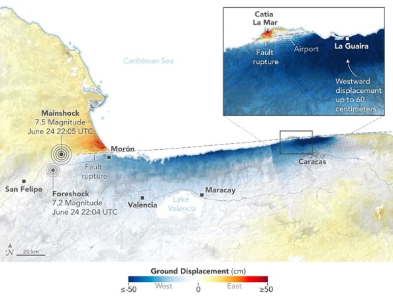
After a series of strong earthquakes that occurred on June 24, 2026, in northern Venezuela, the NISAR satellite detected significant shifts in the Earth's surface. In some areas, they reached 60 centimeters, specialists reported [NASA](https://science.nasa.gov/earth/earth-observatory/where-venezuelas-earthquakes-shifted-the-ground/). On that day, an earthquake with a magnitude of 7.2 struck the region, followed by a main shock with a magnitude of 7.5 less than a minute later. As a result of the natural disaster, people lost their lives, and the most severe destruction was recorded in Caracas, La Guaira, and other towns along the northern coast of the country. The displacement map was created by scientists based on data from the NISAR satellite (NASA-ISRO Synthetic Aperture Radar). The InSAR method was used for analysis, which compares satellite images taken before and after the earthquake and allows for the detection of even small changes in the position of the Earth's surface. For the study, images obtained on June 13 and 18 were compared with images taken on June 25 and 30, after the earthquakes. The resulting map shows the direction of surface displacement. Red areas indicate ground movement upward and to the east, blue areas indicate downward and to the west, while white zones indicate minimal changes. Since the earthquake occurred on a strike-slip fault, the majority of the deformations were horizontal. Particularly strong displacement was recorded south of the international airport north of Caracas, where the surface shifted approximately 60 centimeters. "This is why the damage in Caracas and La Guaira was so extensive. The InSAR technology tells us a lot about what happened during this earthquake," noted geophysicist Eric Fielding from NASA's Jet Propulsion Laboratory. The data has already been used by the U.S. Geological Survey to refine the fault rupture model. This allows for a more accurate determination of how the displacement of rocks underground spread and why some areas were significantly more affected than others. The maps were prepared as part of the NISAR Urgent Response system, which enables the acquisition of preliminary satellite data within 12–24 hours after a natural disaster. For the NISAR mission, this was the first case of rapid mapping of surface displacements after such a powerful earthquake. Satellite observations help not only to analyze the consequences of already occurred earthquakes but also to improve risk assessment and response methods for future natural disasters.